MEDIA | January 12, 2010
2010 M7.0 Earthquake in Haiti
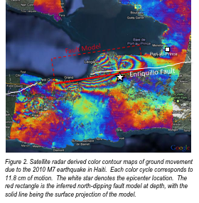
Satellite radar derived color contour maps of ground movement due to the January 12, 2010 M7 earthquake in Haiti. Each color cycle corresponds to 11.8 cm of motion. The white star denotes the epicenter location. The red rectangle is the inferred north-dipping fault model at depth, with the solid line being the surface projection of the model.