Standard Displacement Products
Shall target:
- Earthquake community,
- Volcano community,
- Ground water community,
- Sea-level rise and subsidence community
Shall be defined:
- Spatial and temporal consistent, i.e. no gaps in space and time between products over a defined area of interest in ARIA
- Processed with precise orbits for Sentinel-1
- Geographical scope of 60°N-60°S latitude + USA
- GIS-compatible
The product is packaged as a Netcdf4 file guided by file structure as is planned for the NISAR mission. The top-level group of the product is called “science”, which has a “grids” group containing the geo-coded datasets and a “radarMetaData” group containing specific information related to the SAR data. Within the “grids” group a distinction is made between a “data”, “imagingGeometry”, and “corrections” sub-group. The “data” group contains 2D datasets at 3’’ (~90 m) posting such as the “unwrappedPhase”, the “imagingGeometry” group contains 3D datasets posted laterally at 0.1° (~11km) such as the “incidenceAngle”, while the “corrections” group contains placeholders for potential future layers, such as for ionospheric, tropospheric, and solid earth tide corrections and where the posting is likely to vary depending on the correction. All 2D and 3D datasets are with respect to WGS84 (EPSG 4326). Detailed information on the projection information e.g. wkt is specified under the “crs*” datasets provided under the “data” and “imagingGeometry” groups. At the top-level of the product we also define a “productBoundingBox” as a GDAL compatible wkt polygon. Global attributes provide further information on the product version and citation references.
A description of the different datasets and their sampling is provided in the below, while a file structure for one of the sample products is shown in the figure at the end of this section.
|
Dataset name |
Description |
Posting |
Units |
|---|---|---|---|
|
unwrappedPhase |
2D Filtered unwrapped IFG geocoded |
Lateral = 3’’ (~90 m) |
rad |
|
coherence |
2D Coherence [0-1] from filtered IFG |
unitless |
|
|
connectedComponents |
2D Connected component file |
unitless |
|
|
amplitude |
2D Amplitude of IFG |
watt |
|
|
latitude |
1D latitude sampling (center pixel) |
degree |
|
|
longitude |
1D longitude sampling (center pixel) |
degree |
|
Dataset name |
Description |
Posting |
Units |
|---|---|---|---|
|
incidenceAngle |
3D Incidence angle grid |
Lateral = 0.1° (~11km) Vertical = -1.5, 0, 3, 9km |
degree |
|
azimuthAngle |
3D azimuth angle grid |
degree |
|
|
lookAngle |
3D look angle grid |
degree |
|
|
parallelBaseline |
3D parallel baseline grid |
meter |
|
|
perpendicularBaseline |
3D Perpendicular baseline grid |
meter |
|
|
latitudeMeta |
1D latitude sampling (center pixel) |
Lateral = 0.1° (~11km) |
degree |
|
longitudeMeta |
1D longitude sampling (center pixel) |
Lateral = 0.1° (~11km) |
degree |
|
heightMeta |
1D height sampling |
Vertical = -1.5, 0, 3, 9km |
meter |
|
Dataset name |
Description |
Posting |
Units |
|---|---|---|---|
|
solidEarthTide* |
2D/3D solid earth tide |
TBD |
rad |
|
troposphereHydrostatic* |
3D Tropospheric hydrostatic delay |
||
|
troposphereWet* |
3D Tropospheric wet delay |
||
|
ionosphere* |
2D Split spectrum ionospheric delay |
*Included as placeholder for potential future layers
|
Dataset name |
Description |
Units |
|---|---|---|
|
missionID |
SAR mission |
N/A |
|
productType |
ARIA product type |
N/A |
|
wavelength |
SAR wavelength |
meter |
|
centerFrequency |
Center frequency |
hertz |
|
L1InputGranules |
Reference and Secondary L1 input granules used to make product |
N/A |
|
DEM |
DEM used in the processing |
N/A |
|
slantRangeStart |
Slant starting range |
meter |
|
slantRangeEnd |
Slant ending range |
meter |
|
slantRangeSpacing |
Slant range spacing |
meter |
|
azimuthZeroDopplerStartTime |
Azimuth zero Doppler start time of IFG product for the reference date |
time ISO 8601 |
|
azimuthZeroDopplerEndTime |
Azimuth zero Doppler end time of IFG product for the reference date |
time ISO 8601 |
|
azimuthTimeInterval |
Azimuth time interval |
seconds |
|
ESDthreshold |
ESD coherence threshold applied in the processing, -1 refers to no ESD being applied |
unitless |
|
OrbitType |
Type of orbit, which is “precise” for the UNW IFG GEO product |
N/A |
|
ISCEversion |
SVN/GIT version of the ISCE software |
N/A |
|
unwrapMethod |
Unwrapping method used for generating the unwrapped product |
N/A |
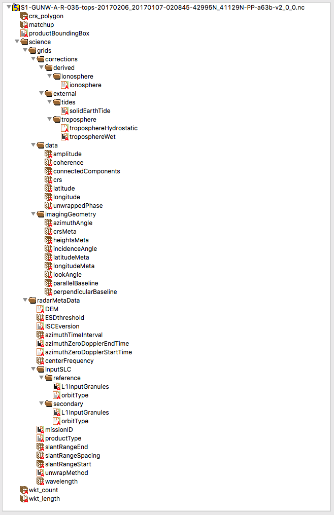
File structure overview of a GUNW product
The L2 GUNW product is generated by ARIA using the ISCE TopsApp processor. The below table provides and overview of the processing parameters.
|
Parameter* |
Value |
Additional information |
|---|---|---|
|
Pairing Direction |
Treference > Tsecondary |
Reference is acquired later in time than secondary. Product sign convention: land uplift corresponds to a range decrease (negative radians). |
|
Temporal Baseline |
N/A |
As large as to meet minimal pairing in time |
|
Perpendicular Baseline |
N/A |
Not considered |
|
Temporal Minimal Match |
2 |
Ensure acquisition date is used at least two times as a reference for different IFG pairings |
|
Orbit type |
Precise orbits |
Degraded orbit quality is not allowed |
|
Azimuth Looks |
7 |
Corresponds to an azimuth posting of 14.5 m*7 = ~101 m |
|
Range Looks |
19 |
Corresponds to a slant range posting of 5 m*19 = ~95 m |
|
Processing DEM |
SRTM and NED |
Use of 30m SRTM for world and 30m NED for USA |
|
Geocoding DEM |
SRTM and NED |
Use of 90m SRTM for world and 90m NED for USA |
|
Enhanced Spectral Diversity Threshold |
0.8-0.5 |
Default is 0.8. If coherence is too low and ESD fails, threshold is relaxed in steps of 0.05 until 0.5 is reached, after which processing is done using orbit information only. |
Overview of the processing parameters.
*Other processing parameters correspond to ISCE topsApp defaults.
Spatial and temporal connectivity
The spatial extend of an individual GUNW product is that of a Sentinel-1 frame. During the interferogram formation one of the two acquisition dates (either the “reference” or “secondary”) will consist out of a single ESA sentinel-1 product, which is referred to as “spatial reference”, while the other acquisition date will use as many ESA sentinel-1 products it needs to cover the “spatial reference” over the ARIA AOI completely.
We explicitly avoid SLC stitching of ESA Sentinel-1 products originating from a different Instrument Processing Facility (IPF). The acquisition date with multiple IPF versions is to be used as “spatial reference”. Note that the derived GUNW products can still be stitched along-track and thus no impact is expected for the spatial connectivity. In case both acquisition dates have multiple IPF versions, the interferogram pairing combination is skipped, and a next available interferogram combination is attempted. This procedure is repeated until the temporal minimal match criteria is met.
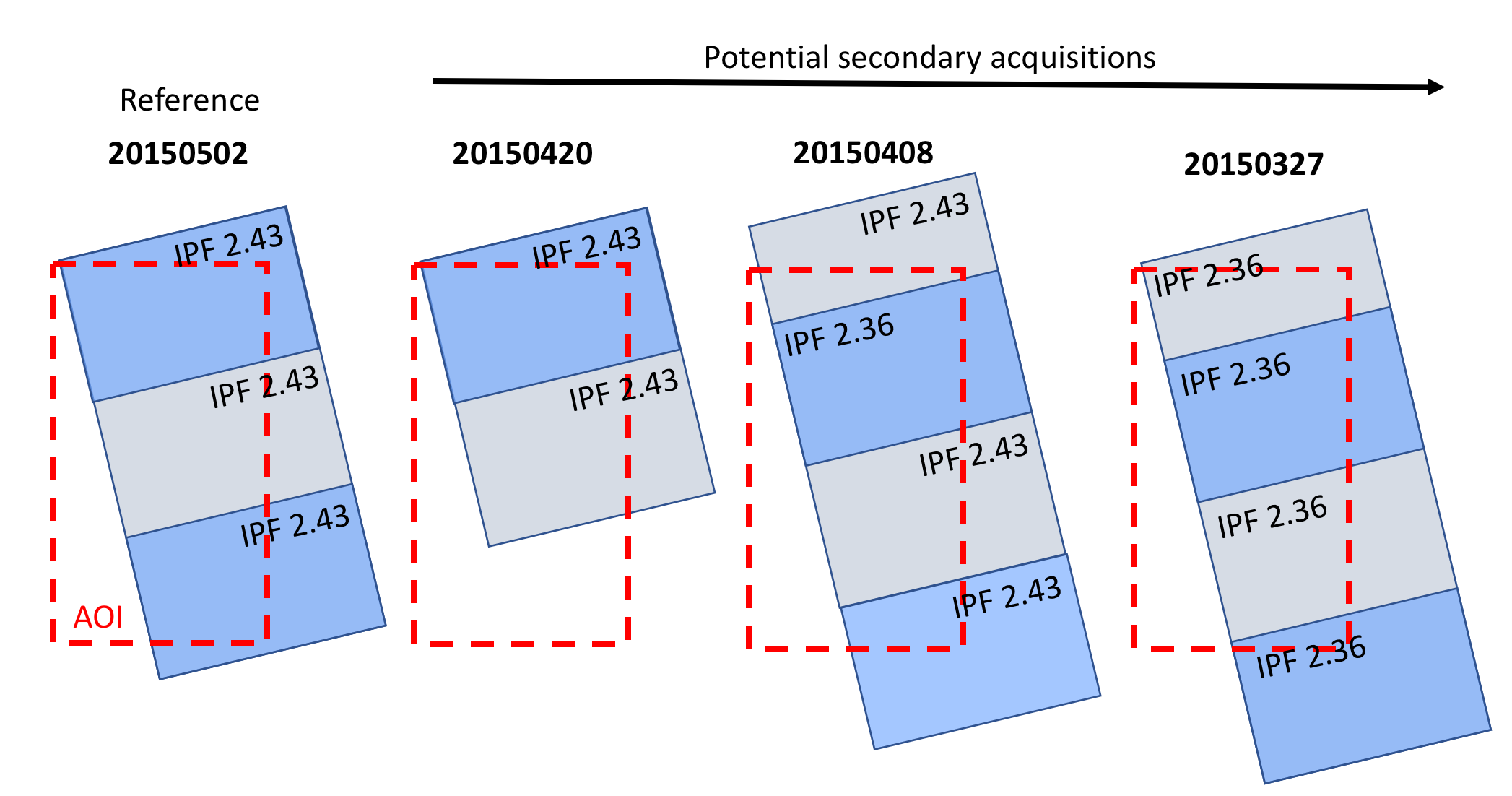
Example of interferogram pairing of a “Reference” with a “Secondary” acquisition with a minimal match criterion set to 2. Following the spatial coverage and IPF pairing rules only the acquisitions made on 20150408 and 20150327 are considered valid for “Secondary”. As the IPF is changing for the “Secondary” acquisition on 20150408, while that of the “Reference” is consistent, the frame definition of the “Secondary” will be used as “spatial reference” for the 20150502-20150408 interferogram, leading to 4 standard products for this pairing. As the IPF is consistent for both the “Reference” and “Secondary” acquisition made on 20150327, the frame definition of the “Reference” will be used as “spatial reference” for the 20150502-20150327 interferogram, leading to 3 standard products for this pairing.
Sensor-DatasetName-A/D-L/R-tracknumber-mode-YYYYMMDD_YYYYMMDD-HHMMSS-XXYYYN/S_XXYYYN/S-PP/RP/PR/RR-systemTag-versionTag.nc
Example:
S1-GUNW-A-R-035-tops-20170206_20170107-020845-42995N_41129N-PP-a63b-v2_0_0.nc
|
Parameter |
Description |
|---|---|
|
Sensor |
Satellite name (string): |
|
DatasetName |
Dataset name of the product (string): |
|
A/D |
Satellite orientation (char): |
|
L/R |
Satellite look direction (char): |
|
tracknumber |
Satellite track (3-digit number): |
|
mode |
Acquisition mode (string): |
|
YYYYMMDD-YYYYMMDD |
Reference and secondary acquisition date (YYYYMMDD): |
|
HHMMSS |
Center time of product in UTC (HHMMSS): |
|
XXYYYN/S-XXYYYN/S |
Decimal latitude of western edge of the south and north most IFG corner (5-digit number with 3 significant digits): |
|
PP/RP/PR/RR |
Precise (P) or restituted (R) orbit precision for respectively reference and secondary acquisition. |
|
systemTag |
data system product tag (unique hash for product) |
|
versionTag |
standard product version tag |
The product version tag captures if changes have been made to the standard product processing workflow. Changes are summarized below. Note that the product version tag is different from the global attribute “version” variable in the NETCDF file which captures changes in the standard product data structure.
|
Product Version Tag |
Description |
|---|---|
|
2.0.0 |
Initial release of standard product |
|
2.0.1 |
Update to use NED over US for processing and geocoding |
Unwrapping Errors
Unwrapping is not trivial. GUNW products are provided as is, with no warranties that the products are correctly unwrapped. It is the user responsibility to apply masking and correct for unwrapping errors that might be present.
Both the “coherence” and “connectedComponent” layers included within the GUNW products act as quality markers for the unwrapping. The “connectedComponent” layer is an output from the unwrapping method which provides more information on the confidence of the unwrapping. Most often unwrapping errors observed within the products occur in regions with low coherence, i.e. connected component 0, or between disconnected regions, i.e. different connected components.
Best practice is to mask out water bodies as well as connected component zero. In addition, it is recommended to inspect if there are multiple connected components left and correct the unwrapped phase where needed.